The Trail.
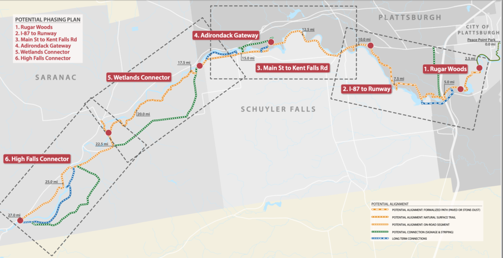
The Saranac River of northern New York has long been a corridor for trade and travel, playing an important role in the development of the region. It winds from the shores of Lake Champlain to the foothills in the Adirondack mountains. The river flows over rocky falls, through quiet forests, wetlands, and past sites of historic significance. The Saranac River Trail Greenway once developed will be a 27- mile network of trails running along the Saranac River from its mouth at Peace Point in the City of Plattsburgh on Lake Champlain to the riverside community of Saranac at the foothills of the Adirondack Mountains. The vision of the Saranac River Trail Greenway is to create a unique recreational network of trails for residents and tourists to enjoy. The Greenway will combine shared-use paths, low volume roadways, natural surface trails, wetland boardwalks and other connections. The Saranac River Trail Greenway is current in development. The present trail runs from the mouth of the river on Lake Champlain to the Imperial Dam.

Check out our maps page to see trail segments and parking areas.
The Organization.
Saranac River Trail Greenway, Inc.’s purpose is to facilitate the development of the Saranac River Trail Greenway. It is a New York State Not-for-Profit Corporation formed in 2012. It has 501(c)(3) status. It works with municipalities and private landowners to enshrine recreational access to land through easements and other rights. If you are a landowner on the proposed greenway or a member of the public interested in getting involved, visit us on our Get Involved page.
History.
The City of Plattsburgh received grant funding to build a paved trail along the Saranac River within its municipal boundaries. This was completed in 2012 with additional spurs added in subsequent years. The concept to expand this trail to a 27-mile greenway was conceived through a feasibility study done by Clinton County in 2016. The result of the study was a report which broadly found that a recreational trail could be built on a combination of public and private land. The feasibility study can be found here.